
Click here to return to Angel Island Main Menu
Angel Island Biking and Hiking on the Perimeter Road
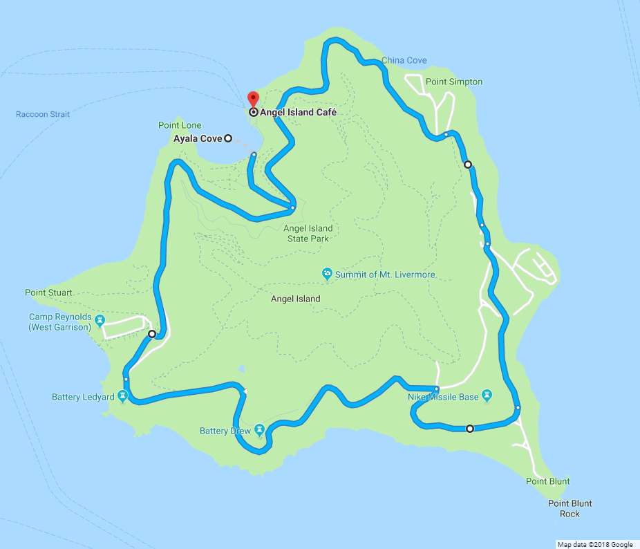
The Perimeter Road is the primary Angel Island biking and hiking route followed by riders, hikers and walkers in Angel Island State Park. If you plan any activities beyond a picnic at Ayala Cove, this is the route you’ll follow for at least some of your journey. The Perimeter Road also connects to single-track hiking paths and some Angel Island biking routes that lead up the hill towards Mt. Livermore.
Once you get past the steep road or trails up the hill from the picnic area, the road along the western (San Francisco) side of Angel Island follows more gentle slopes until steeper slopes return on the southern and eastern sides of the island. The Perimeter Road is paved (with a couple of gravelly spots) and the width of a wide fire road, so it gives Angel Island biking and hiking visitors solid footing as you explore.
How to Get There
Our preferred route for Angel Island biking or hiking is to ride/walk up the steep paved road that leads up the hill near the picnic areas at Ayala Cove, which leads directly to the Perimeter Road. Hikers can also reach the road from Ayala Cove via fairly steep trails, which have steps, at either end of the visitor area. The stairways are located:
- Near the ferry pier to the northeast (to the left as you face the center of the island)
- Beyond the last picnic tables, near the water, to the southwest (to the right as you face the center of the island)
Angel Island bike riders should use the paved road to avoid carrying bikes up the steps. A sign (not far from the bottom of the hill) will mercifully direct you to turn left onto an Angel Island biking path that gives you a more gentle slope as you ride up the hill to Perimeter Road
Insiders Tip: The Angel Island Tram Tours and the Segway Tours also circle the Perimeter Road, and occasionally you’ll encounter them right in front of you as you come around a corner. They drive slowly and you can hear them coming, but just keep an eye out for them and remind kids to do the same.
The Most Popular Angel Island Biking & Hiking Routes
The Perimeter Loop — This route is about 5.5 miles (9 km) long, most of it on a paved asphalt road, and it both starts and ends at Ayala Cove. The road has gradual uphill and downhill sections (none as steep as the short road that leads up the hill from Ayala Cove), and many reasonably level stretches as well. There are a few places where the road has broken down and you’ll find gravel and small rocks on the surface, but none of these are very long and you’ll soon return to a paved road. Nevertheless, bike riders and walkers will want to use caution in these spots to avoid falls.
The Perimeter Loop offers all of Angel Island’s fabulous views: the Tiburon peninsula, the Golden Gate Bridge, San Francisco’s dramatic skyline, Alcatraz, the Bay Bridge, and the Berkeley Hills. (You can also see the Richmond – San Rafael Bridge, but no one has ever called that asymmetrical humpback abomination a fabulous view!) We like to pack a lunch and eat at one of the picnic tables scattered along the route.
The View Area below Battery Ledyard — Battery Ledyard is an old gun emplacement used in the defense of San Francisco Bay from the Civil War times until about 1915. It’s at the bottom left of the map above.
The section of the Perimeter Road above Battery Ledyard has a wide picnic area at the side of the road, with wooden picnic tables and incredible views of both downtown San Francisco and (the view that gets the most photos) the Golden Gate Bridge. It’s about a 1.4 mile (1.8 km) trip each way from the ferry on your Angel Island bike ride or hike, which makes it just short of a 3 mile (4.5 km) round trip. There are many other great views of the Golden Gate Bridge and the Bay en route, so the whole trip is beautiful.
Insiders Tip: Actually, two tips:
- If you plan to go only as far as the Golden Gate Bridge view spot near Battery Ledyard on your Angel Island biking or hiking adventure: There are many great vistas from the island. Since the Perimeter Loop is 5.5 miles, and the round trip total for just going to the Golden Gate Bridge view spot is almost 3 miles, why not just do the whole loop and see more?
- If the kids (or you!) used up all their (or your!) energy to come up the hill as far as the Golden Gate Bridge view spot, don’t feel bad about just going back to Ayala Cove. The Perimeter Road rarely is level for very long, and there are still a couple of significant climbs you’d encounter doing the entire perimeter road loop if you want to go all the way around the island.
If you have small kids or if someone in the group is tired after reaching the view area, a picnic on the benches above Battery Ledyard will restore them. Riding or walking back from the Battery Ledyard view area the way you came means you’re mostly going downhill on a paved road all the way back to the ferry, with just a few gentle uphill parts.