
Did you just feel an earthquake in Sausalito?
The following link takes you to the website with the United States Geological Service’s latest Northern Calirnia earthquake information. If an earthquake has occurred it will be shown on a list, with an entry you can click on for data about the quake. A non-interactive sample showing what the map is like is below (with a non-Sausalito locale to avoid its being confused with a live map).

Can we really have 95 earthquakes in one day? All the time! Most quakes are too small to feel, or you’ll just think a big truck drove by. We rarely get quakes big enough to actually recognize as quakes. And, as everyone knows, every few decades we get a big one, which is why we all want to know the basic rules of what to do in an earthquake.
Sausalito Earthquake Safety and Liquefaction Map
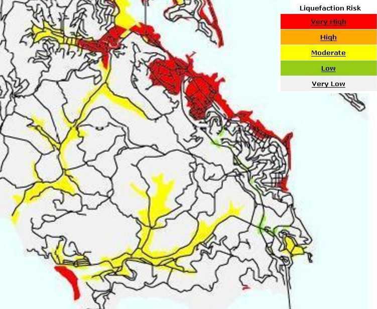
Where does your house stand on the liquefaction risk map?
“Liquefaction” is a process that can take place when:
- A low-lying area of land has been filled in by human development in recent years, or by natural landslides or floods going back for millennia, and
- Either salt water or fresh water is present beneath the surface.
.
In an earthquake this less-solid ground can shake so much that the water coating the grains of sand start to act like a lubricant, turning the material from a solid into something that behaves like mud — even if the particles are actually non-porous sand.
In the Bay Area we learned to think about liquefaction when the 1989 Loma Prieta Earthquake created so much damage in the Marina District of San Francisco. The area once was marsh and open water, but was filled in to create land for the 1915 Pan-Pacific Exposition, a World’s Fair designed to show everyone that San Francisco had been reborn from the ashes of 1906. Many apartment buildings built after the disassembly of the Exposition collapsed when the filled-in soil below them proved vulnerable to liquefaction.
Damage was exacerbated because cars had recently become affordable by everyday people and the ground floors of these buildings consisted of garages with weaker stabilizing interior walls.
The map above, which comes from the USGS website, shows which areas of Sausalito have soils that are prone to liquefaction in a major earthquake. As you can see, most of the highest risk areas shaded in red are in the Marinship area, which was filled in for the building of the wartime Marinship shipyards in 1942. Other areas along Bridgeway in New Town and Old Town were also filled for ferry piers and to create new space for housing and businesses in the late 1800’s.
By zooming in on the map you should be able to see the modern streets well enough to determine if a specific block of Sausalito real estate is prone to liquefaction in a future major North Bay earthquake.