


Rising Sea Levels: San Francisco Bay and Sausalito
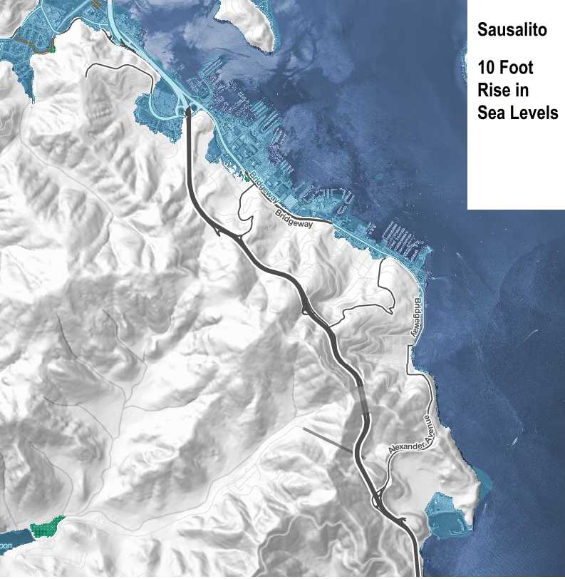
It may take a hundred years or more to happen, but Climate Central has published a map of local areas that would be flooded by a 10-foot rise in world sea levels. Click on the map above to enlarge it and zoom in on the areas shaded in dark blue, which would be inundated. The interactive map, which runs on the Microsoft Edge browser but not on Google Chrome, can be found here.
We also have a map of the zones vulnerable to tsunamis at the botttom of this page.
.
The hope, of course, is that we’ll be able to figure out how to stabilize the climate and summon the will to do so before these dire effects arrive.
If you’re Michael Bay or you enjoy truly catastrophophic charts, check out Geology.com’s sea rise map of San Francisco Bay, which lets you raise the oceans up to almost 200 feet (60 meters). In that scenario only the elevation of the Tennessee Valley Trail’s trailhead area keeps Sausalito and southern Marin from becoming an island.
If you’d like to do a deep dive into the data and issues, there’s a detailed report by the State of California about rising sea levels in California here.
The good news (if you read it out of context) about a 10-foot rise in sea levels:
The majority of Sausalito residents live on rises, hills or houseboats and would still be OK.
Cavallo Point would become a beach resort, with the water lapping at the base of its front lawn.
Parts of Caledonia St. would become waterfront property.
Our Floating Home communities would need to raise their docks, but apart from that they’d be… Well, they say a rising tide floats all boats!
The bad news about that 10-foot rise:
Those who live and work right on the Bridgeway Promenade and in Downtown Sausalito and on Bridgeway near Caledonia St. would gradually see homes and offices under invasion by water.
The Marinship office and industrial area (where OurSausalito.com has been based for the last eight years), which consists of Bay marshland and shallow waters hastily filled in during World War II, would be flooded, especially the northern Marinship area and the lower reaches of Nevada Valley. This would lower our office rent but have other less positive consequences.
The real Bay would invade the Bay simulator at The Bay Model.
The Coast Guard station and Bay Area Discovery Museum on the shores of Fort Baker would be flooded.
Obviously, just about everything about this scenario is bad news!
The Historical Data
Click on the chart to enlarge it.
Mean Sea Level Trend
9414290 San Francisco, California

According to NOAA, the average rising sea level trend is 2.01 millimeters per year (about 1 inch every 12.5 years), based on monthly sea level data collected for tide tables from 1897 to 2006. That adds up to an increase of 8 inches in 100 years.
As the chart shows, the data goes back to 1853, but something about the methodology was changed in the 1890’s so they just use the last 115+ years for their estimates. That said, the 1853-1897 data appears to correlate with the later patterns.
Source: NOAA Tides and currents website.
What About Tsunamis?
The map below suggests areas that are most vulnerable to a tsunami, though it’s key to remember that the damage from a tsunami can vary greatly based on the angle and direction at which it enters San Francisco Bay. Looking at the map below is useful for general preparedness, but not necessarily accurate for any individual tsunami.
Click here for videos of the Japanese tsunami surge reaching Sausalito in 2011 after crossing the northern Pacific Ocean. It’s trivial compared to the videos from Japan, but a reminder that even distant earthquakes can generate a tsunami.
Insiders Tip: As we all learned watching the horrifying videos of the Japanese tsunami in 2011, the only real way to be safe from a big tsunami is to get to high ground, and the EarthquakeCountry.org emergency site recommends that this means 100 feet (30 meters) above sea level.
The “safe area” in the map below is far below that “eliminate all doubt, get 100 feet up” guideline. If a tsunami alert is called or a big earthquake hits, don’t just get out of the low lying areas of Sausalito. Go higher up the hills so you’re safe from any angle of approaching waves.
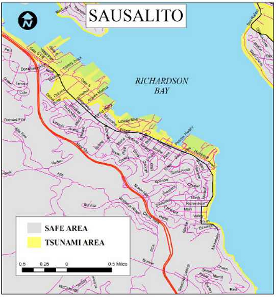

Source: EarthquakeCountry.org
