

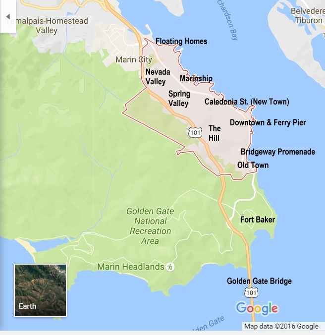
Next Neighborhood North: Caledonia (New Town)
Next Neighborhood South: Bridgeway Promenade
Next neighborhood up the Hill to the West: The Hill
Click here to return to the Neighborhoods Index
(The video above includes sites both directly north and south of Downtown as well)
Downtown Sausalito
This is one of a series of pages on each of Sausalito’s Neighborhoods, with links to Restaurants, Hotels, Bus Stops and Activities in each area.
The few short block of Downtown Sausalito near the Ferry Pier are the area in Sausalito that is familiar to most visitors. For Ferry riders this is where they embark and disembark. For visitors who drive it’s the location for most of the large City parking lots. The stone elephants (pictured above) and fountain in Viña del Mar Park are famous symbols of the city.
This area is home to some of our best restaurants, as well as four unique hotels. Along with the Bridgeway Promenade just to the south this area offers some of Sausalito’s best views. The Ferry neighborhood runs along Bridgeway from Caledonia St. in the north (see the map below) to Princess St., although in the eyes of some people Downtown Sausalito runs another 100 yards down the Bridgeway Promenade.
See the bottom of the page for a street scene from 1925 and an aerial view of the area in 1965.
Downtown Sausalito Restaurants
| Bacchus and Venus (Wine Tasting) |
| Copita (Mexican) |
| Fish and Chips of Sausalito (Fish and Chips) |
| Hamburgers (Flame Grill) |
| Lappert’s Ice Cream (Ice Cream) |
| Napa Valley Burger Co. (American) |
| No Name Bar (Nightly Music) |
| Poggio Trattoria (Italian) |
| The Spinnaker (Seafood) |
Downtown Hotels
| Casa Madrona |
| Gables Inn |
| Hotel Sausalito |
| Inn Above Tide |
Bus Stops
(Click here for more information)
| Anchor at Humboldt (Ferry) — Served by different lines than most Bridgeway stops |
| Bridgeway at El Portal (HUB — Southbound) |
| Bridgeway at Bay (HUB — Northbound) |
Downtown Sausalito Landmarks
Old Photos of Downtown Sausalito
Here’s what the area looked like in 1905, when what is now called Vina del Mar Park had just been laid out but not yet developed. The trains at the left, which connected to Mill Valley and San Rafael, sit where the parking lot next to the ferry pier is located today. (Click to enlarge image)

The photo below (taken looking north from the intersection of Bridgeway and Princess St. 20 years later) shows downtown Sausalito in the 1920’s, and to locals it’s still instantly recognizable despite all the architectural changes over 100 years. I walked down this street today when I went to get a sandwich for lunch.
In the distance on the right side of the street you can see the elephant statues and palm trees of Vina del Mar Park. The “Tailor” sign at left is over what is now an art gallery and tasting room at the corner of Bridgeway (then called Water St.) and Princess.

The downtown area in Sausalito as it appeared in about 1965, as seen from the air. An old ferry is moored at center left, the same location served by modern ferries, but this photo dates from the 1941 to 1970 interregnum when no ferries sailed to San Francisco. The large white building in the center is the old Village Fair, now converted into part of the Casa Madrona Hotel and Poggio Trattoria. The Golden Gate Bridge, then less than 30 years old, is at the top.
