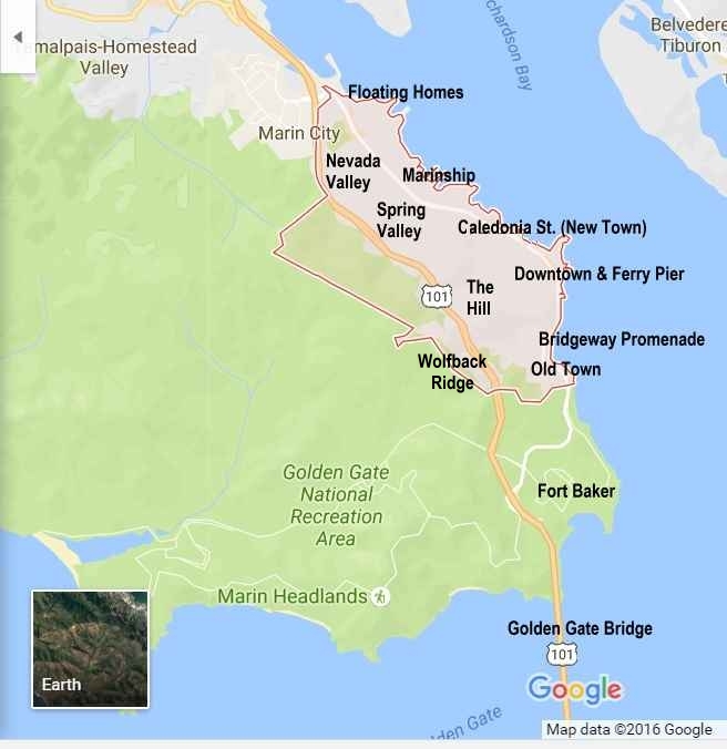
Sausalito Neighborhoods
Every Sausalito neighborhood has something to offer both residents and visitors. The pages below link to Restaurants, Hotels, Activities, Landmarks and Transit in each of the very different Sausalito neighborhoods. See the map above for the location of each neighborhood. This list runs from south to north along the shoreline of San Francisco Bay.
 Fort Baker and the GGNRA — The wide expanse of former military bases on the northern side of the Golden Gate, now converted to public parks and a hotel complex on Sausalito’s southern border. The community of Muir Beach, to the west, on the shore of the Pacific Ocean, shares Sausalito’s 94965 Zip Code and lies within the GGNRA.
 Old Town — The original “Whaler’s Cove” where Sausalito first began as an outpost in old California almost 200 years ago, now (logically) the oldest Sausalito neighborhood and the southern edge of town. Many homes here have stunning views, although the area is also (to the horror of every Realtor in California) referred to as “Hurricane Gulch” because of cool afternoon winds, especially in the summer. Two generations of our family have lived in this neighborhood at various times and we loved it here.
 Wolfback Ridge — This small residential Sausalito neighborhood of large homes perched high on the cliffs on the west side of Highway 101 above Sausalito has some of the most expansive — and expensive — views in the Bay Area. On foggy days nature invites residents to turn inward for inspiration since the windows can look like the inside of a box of cotton balls for a few hours.
Bridgeway Promenade — The southern section of Downtown Sausalito, where Bridgeway runs directly along the Bay. Home to some of Sausalito’s most famous views and best-known restaurants. Although this Sausalito neighborhood mostly is occupied by storefronts, there are also some newer big-view high-price homes here. The Bridgeway Promenade itself has two levels of walkways (at low tide) or one level (at high tide), depending how you look at it. In either case, the Promenade runs along the rocks on the shoreline of the Bay.
The Hill — Above Downtown Sausalito and The Bridgeway Promenade lies The Hill, a prestigious old Sausalito neighborhood with sweeping views of The Bay and (depending on where you are on the ridge) San Francisco. This is where William Randolph Hearst planned to build his personal castle until clashes with town leadership led him to abandon Sausalito and build Hearst Castle in San Simeon instead. It’s also a mix of everything from big mansions to tiny cottages. Our family lived in this neighborhood at one time.
 Downtown Sausalito (Ferry Pier) — At the base of The Hill lies the heart of downtown Sausalito, with top restaurants, an eclectic assortment of shops, the major city parking lots and the Ferry Pier. This is the Sausalito neighborhood where most visitors either park their cars, lock up their bikes or arrive by ferry to start their visit to town.
![]() Caledonia St. (New Town) — Sausalito’s “hidden downtown” frequented by residents, home to a wide variety of restaurants, City Hall, the Sausalito Library and small locally-focused retailers. It’s called “New Town” because it was developed in the late 1800’s, 50 years after the original construction of Old Town. Many of the homes on the lower part of the hill above Caledonia St. also date back over 100 years, with newer houses on the higher slopes. Our family lived in this neighborhood at one time.
Caledonia St. (New Town) — Sausalito’s “hidden downtown” frequented by residents, home to a wide variety of restaurants, City Hall, the Sausalito Library and small locally-focused retailers. It’s called “New Town” because it was developed in the late 1800’s, 50 years after the original construction of Old Town. Many of the homes on the lower part of the hill above Caledonia St. also date back over 100 years, with newer houses on the higher slopes. Our family lived in this neighborhood at one time.
 Marinship — The area developed as part the old Marinship shipyard, now home to a thriving artist community, offices and light industrial buildings. Many of the World War II buildings have been modernized and can be seen by walking around the area today. Home of the Bay Model, a massive working simulator of San Francisco Bay and the Delta that uses real water to simulate the effects of environmental and human-created changes in the environment. OurSausalito.com has been based in a series of offices in this neighborhood over our nine year history.
 Spring Valley — A hillside residential Sausalito neighborhood in the valley just north of the Caledonia St. area. Many homes here have great views of Mt. Tamalpais and Richardson’s Bay, the northwest arm of San Francisco Bay.
Nevada Valley — This bowl-shaped valley in northern Sausalito features hillside homes and apartments as well as several schools. A majority of the homes in this area have views of Richardson’s Bay, and many also look out at Angel Island or Mt. Tamalpais.
Floating Homes — This concentrated area of specially constructed docks at the northeast corner of Sausalito is home to hundreds of Sausalito’s floating homes and houseboats. These homes range from converted old wooden working boats to purpose-built architectural gems. The community here is a mix of artists, musicians, professionals and retirees, and most of the docks are close-knit, supportive communities.
 Marin City and Pohono St. — The northernmost of Sausalito neighborhoods, Marin City is a deeply-rooted community created as a housing area for the workers at the Marinship shipyards in World War II. Some residents today are descendants of those same workers. Now the site of apartments and townhomes, as well as a regional shopping center anchored by Target. The large bus stop is a hub for Golden Gate Transit and Marin Transit bus service.