
Click here to go to the Golden Gate Bridge Menu
Biking the Golden Gate Bridge & Sailing Back on the Sausalito Ferry
Click here for current Sausalito ferry schedules for Golden Gate Ferry and Blue & Gold Fleet
Many visiting riders don’t realize that instead of braving dangerous portions of Alexander Ave. (AKA The Sausalito Lateral) you can take a beautiful, far safer route for biking the Golden Gate Bridge and then riding down the hill to Sausalito. We give you all the details below.
You can rent a bike in San Francisco or bring your own, and biking the Golden Gate Bridge to the Sausalito Ferry offers views that are simply breathtaking. You can return to the Ferry Building or Fisherman’s Wharf in San Francisco by ferry, and your bike rides with you on the trip back.
Can you ride an e-bike on the Golden Gate Bridge? E-bikes have now been accepted as OK to ride on the Golden Gate Bridge sidewalks, so long as you stay under the 15 MPH speed limit for regular bikes and follow all the other rules for bikes (yield to pedestrians etc.). E-bikes are not allowed in the traffic lanes on the Golden Gate Bridge.
Insiders Tip: There are no bikes available for rent at the Golden Gate Bridge itself. You’ll need to rent bikes in San Francisco or Sausalito and then ride to the Bridge.
It’s about an 8 mile trip starting from Fisherman’s Wharf in San Francisco and biking the Golden Gate Bridge to the Ferry pier in Sausalito. The trip usually takes 2 to 3 hours, which is nothing for avid cyclists but means you’ll be sore at the end if you haven’t been on a bike for a while! There are paid and free bike racks in Sausalito near the ferry, but make sure you get a bike lock with your rental.
Insiders Tip: Although biking the Golden Gate Bridge all the way to Sausalito and taking the ferry back is a popular route, you can also cross the Bridge, turn around and ride back into San Francisco. Follow our guide below, and when you reach Vista Point or the Conzelman Road Parking Lot at the north end of the Bridge you can simply turn around and ride back. Of course, you’ll be missing all the wonders of Sausalito, which this website is dedicated to sharing with you! (No, I’m not crying… you’re crying!)
If you elect to ride back to San Francisco after descending the hill into Sausalito instead of taking the Ferry there are different tricky spots and no signs for which way to go after you climb a steep hill — we give you directions on this special page about taking the southbound route across the Bridge. This is a better choice on an e-bike unless you’re good at long climbs.
During Summer and Holidays there may be delays in bikes boarding ferries in Sausalito due to the large number of visitors. (See also our complete Ferry Guide) .
Be prepared for strong, cold winds when you’re biking the Golden Gate Bridge throughout the year — In all four seasons make sure you have layers of clothing and a windbreaker or something else to help stay warm, especially on the Bridge itself. The Bridge has its own weather patterns that can be very different from standing on the bluffs on either side of the Golden Gate.
Where do we stop in Sausalito? If you’re just going as far as the Sausalito Ferry, turn right at the center of downtown Sausalito and park your bike when you see the two elephant statues and a fountain in the park . See “How Far Do We Ride?” below for more details on longer rides.
What You Can’t Do: Skateboarding, rollerblading and anything else with wheels except a bike are prohibited on the bridge. In recent years e-bikes became OK to ride so long as you stay under the 15 MPH speed limit for regular bikes.
Bike Access Schedules: Bikes have 24-hour access to the Bridge, but have to use different sidewalks at different times. Click here to see the current access times. Construction schedules on the Bridge add further changes to these schedules.
Insiders Tip: The Golden Gate Bridge administrators have a page with Special Updates for biking the Golden Gate Bridge when construction or other issues change the usual rules for the Bridge sidewalks.
How Long is the Golden Gate Bridge? We have that answer and many more here!
Biking the Golden Gate Bridge from San Francisco
Starting from anywhere along the northern waterfront of San Francisco, you can now take the new bike path along the Bay past the Embarcadero, Fisherman’s Wharf, Aquatic Park, Marina Green and Crissy Field towards Fort Point.
The map below shows the entire route from Fisherman’s Wharf for biking the Golden Gate Bridge to the Sausalito Ferry. You can zoom in on any part of the San Francisco waterfront to see the streets and bike paths that run along or near the water’s edge. (Yes, the zoom really does get that close!) We have detailed maps below for some sections of Sausalito that will guide you there.
The Bridge offers great views of San Francisco, Angel Island, Alcatraz and the sailboats on San Francisco Bay. On the ocean side the rugged cliffs of the GGNRA and the Marin Headlands, crashing surf and dramatic fog and clouds are stunning.
On weekends and holidays bikes have free access to the west (ocean side) sidewalk of the Bridge (click here for schedule), and pedestrians are restricted to the east sidewalk — this makes the bike ride fast and efficient, although you’ll want to stop and take in some of the great views.
On weekdays before 3:30 PM maintenance crews are working on the west side and bikes have to take the Bay-side (east) sidewalk, where there are often lots of pedestrians. As Tom Stienstra of the Chronicle put it, before 3:30 PM weekdays be ready to “go slow, be courteous and prepare to stop for the Kodak moments.”
If you want to visit the other sidewalk of the Bridge before you start or after you finish your crossing, a passageway beneath the Bridge allows you to do so. Stairs descend to a tunnel / catwalk from the Vista Point and the Conzelman Road parking lot (in the north) and there’s a path to a tunnel leads from the view area at the south parking lot next to the toll plaza.
If you’re an experienced rider on a quality road bike, the old route with the fast descent down the Sausalito lateral is described here.
The Safer Route to Sausalito after Biking the Golden Gate Bridge
We recommend the Conzelman Road route to Sausalito for visitors biking the Golden Gate Bridge due to its greater safety and even more beautiful views than the old route, which has speeding cars and a narrow shoulder.
When this bike and pedestrian path was completed in 2014 it allowed us to cut several paragraphs of text on this page about how to maneuver safely through the dangerous old route. Here’s how to take the safer path:
After crossing the Bridge on the west (ocean side) sidewalk, you’ll see a marked bike path that leads through a small parking lot (shown below). If you crossed on the San Francsico-facing sidewalk, a tunnel beneath the Bridge connects the Vista Point parking lot with the Conzelman Road parking lot (click here for complete information), shown below.
Do not ride up the hill. Instead, cross the parking lot towards its downhill corner, which is at the middle right of the photo above.
When you reach that corner of the Conzelman Road parking lot you’ll see a gate that blocks cars from passing, but that allows bikes and pedestrians to proceed. Signs give the distance to Fort Baker and to the Sausalito Ferry pier. This gate is shown in the picture below.
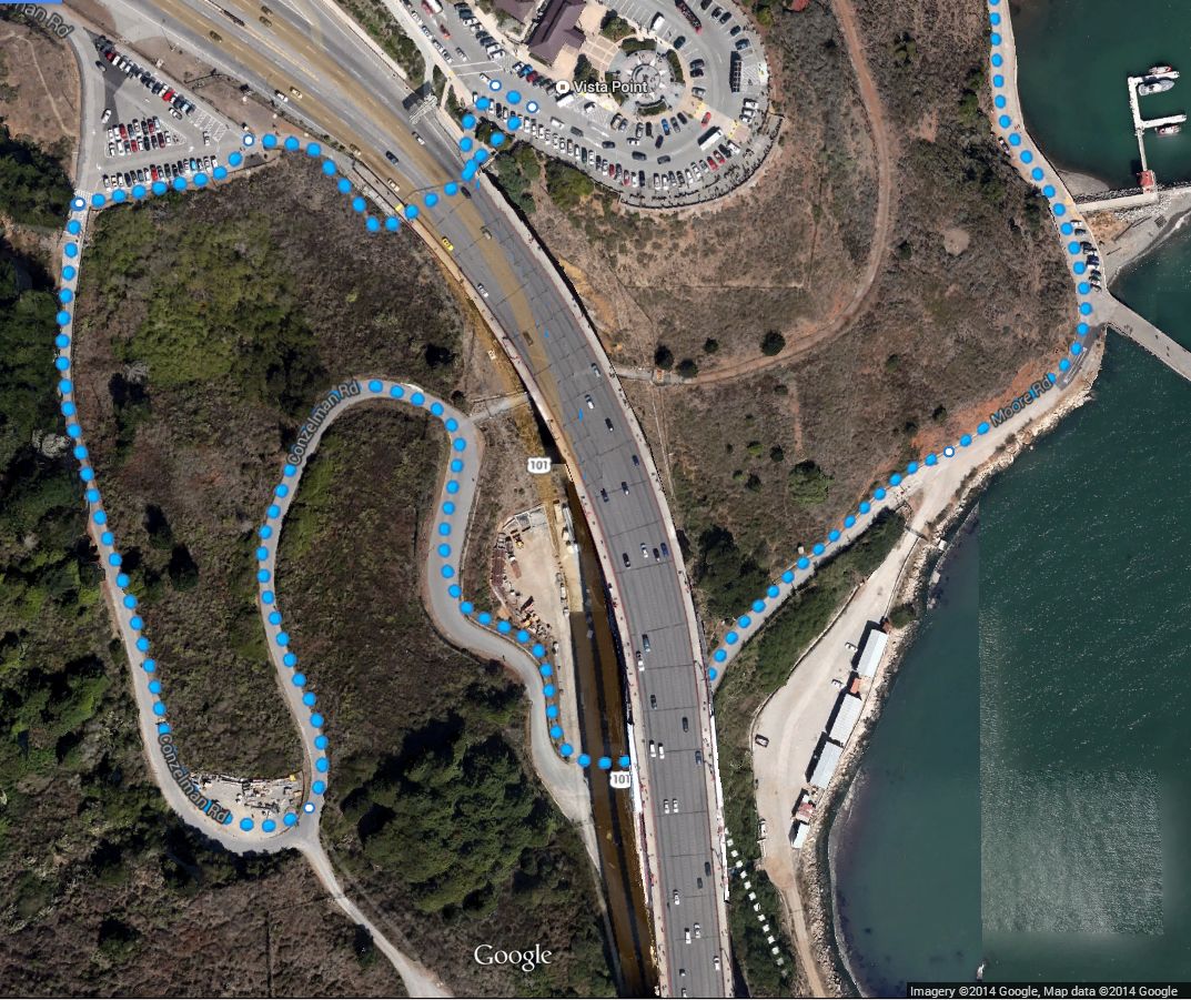
Google Maps had a hard time displaying this path correctly, so to make it ultra clear for you I took a screen shot of the map, edited it to remove some bizarre lines that their website added that led nowhere, and included it below. The Conzelman Road parking lot shown above is at the upper left, Vista Point is at the upper right. You can click on the image to enlarge it.
Follow the bike path past the gate shown above and it will take you down a road that is only for bikes and pedestrians that goes beneath the Bridge and into the Fort Baker area of Sausalito. The path is steep in places so proceed with caution.
After winding down the hill, this path connects with East Road, which runs close to the Bay, with glorious views of the Golden Gate Bridge. You’ll recognize spots where some famous photos were taken.
Insiders Tip: When you are riding inside Fort Baker you can always tell which way you’re going with a simple trick: if the Bay is on your right you are riding towards Sausalito, and will eventually rejoin the Sausalito Lateral just before it enters town. If the Bay is on your left you are riding towards the Golden Gate Bridge… but unless it’s super-foggy you’ll be able to see the Bridge almost all the time!
Note: Here’s the same route marked on a map as opposed to a satellite image, in case you find that easier to read. (As with the first image, the map below is a copy of a screen we could not get the Google Maps system to export since it wasn’t their preferred path, and is Copyright 2024 by Google. We use it here for informational purposes only.) Although Google doesn’t think this is the best path for bikes and hikers, it was built explicitly for bikes and hikers and is the best way to go. You can click the image to enlarge it.

Descending the Final Blocks & Entering Sausalito
This section is important for families riding with kids and for less experienced riders. This section applies both to the (experienced rider) Alexander Ave. / Sausalito Lateral Route and the (more scenic) Fort Baker route, since they rejoin just above this narrow stretch of road.
When you first reach the outskirts of the town of Sausalito the road descends steeply as it goes through about 2 blocks of a very narrow, very busy street (shown at the bottom of the satellite image below). There is a sharp, blind curve as you turn left where Alexander Ave. transitions into South St. If you are riding with kids you’ll want to supervise them closely or walk your bikes in this narrow 2-block segment.
The traffic coming up the hill is making a blind turn at this spot, there are wide commuter buses going both ways on the narrow street, and much of the year in the afternoon the sun blinds the oncoming drivers as they turn uphill. Enough said about why you want to be very careful in this spot!
After this sharp left turn and one more right turn you’ll be riding downhill on 2nd St., the last slope before the flat area in downtown Sausalito. There are crosswalks in this area, and when cars stop for pedestrians in these crosswalks they often surprise high-speed bike riders who have been drafting behind them.
We’ve seen many near misses and multiple accidents. Please be ready for cars making sudden stops as you complete your descent into town.
The Reward: One of the Best Views in the World!
After that last choke point you’ll round a corner, descend a short section of street and see the bench and view shown in the photo above, along with other nearby benches. You’ll be riding right next to the Bay in one of the most beautiful spots in the world! From here on you’ll be on normal (crowded) city streets. We refer to the bench pictured above as “The Conference Room” because of lunchtime meetings we have here!
Follow the main road, now called Bridgeway (the main north-south street in Sausalito) in honor of the Golden Gate Bridge. This area is the Bridgeway Promenade. There are benches along the edge of the Bay here, and you can buy sandwiches at nearby deli’s for an inexpensive impromptu picnic!
To reach the Sausalito Ferry for your return to San Francisco, take Bridgeway north (the Bay will be on your right hand side) to the intersection with El Portal (by the little park with the fountain, Vina del Mar Park) and turn right to reach the Ferry pier. Our Downtown Sausalito page gives you all the information on this area.
Do not ride your bike on sidewalks in Sausalito, since this is prohibited (and dangerous) and you could get a ticket.
Insiders Tip: If you stop to eat lunch at a restaurant in Sausalito, make sure you lock your bike and take valuables with you, as you would in any other city.
How Far Do We Ride?
Insiders Tip: If you’re NOT going to see the large group of Sausalito houseboats, the Bay Model or plan a longer ride to Mill Valley (see below), you’ll probably want to park and lock your bike in downtown Sausalito or just to the north on Caledonia St. (directions below). These are the best “home bases” from which to explore, and many popular spots are within walking distance.
Insiders Tip: When you reach a small park with a fountain and two elephant statues in front you’re in the heart of downtown Sausalito, and the ferry pier is one block to your right. This is where most visitors stop to explore the shops in town, and there are many free bike parking racks near the Ferry pier.
Here’s the map showing the area near the ferry pier at the corner of El Portal and Tracy Way:
Biking the Golden Gate Bridge Back to San Francisco
We now have a page dedicated to this route.
Longer Bike Rides Through Sausalito
If you want a longer bike ride after reaching Sausalito (and having a fabulous lunch or snack!), here’s our page on riding from Sausalito through Mill Valley to Tiburon.
The Ferry Back to San Francisco
Be sure to check out our Sausalito Ferry Guide for links to current schedules and a guide to which ferry you want to take after biking the Golden Gate Bridge to Sausalito. We also have tips for how to make the bike boarding process easy.
Some bike rental shops in San Francisco are closest to the terminal for the Blue and Gold Fleet at Fisherman’s Wharf, while those near the Ferry Building are closest for Golden Gate Ferry voyages.
The ferry crew will advise you where to stow your bikes on board.
Insiders Tip: If you’re visiting during the summer months there are extra ferries added to the schedule in the late afternoon, when over 1,000 bike riders may be looking to return to San Francisco.
If you have theatre tickets or dinner reservations in San Francisco the night you make this ride, try to make your bike trip earlier in the day so you avoid the crush at the ferry pier after 4:00 PM.