
Click here to return to the Neighborhoods Index

Next Neighborhood North: Downtown Sausalito (Ferry Pier)
Next Neighborhood South: Old Town
Next neighborhood up the hill: The Hill
The Bridgeway Promenade

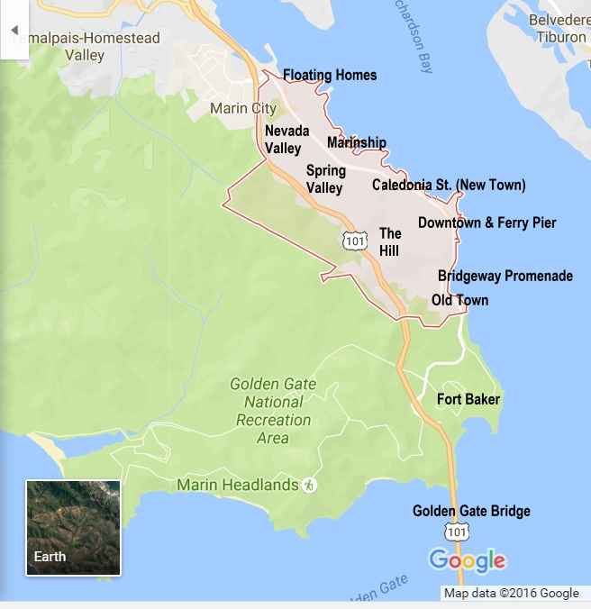
Most of the “fantastic Sausalito view” photos you’ll see on social media were taken from the Bridgeway Promenade, which runs along the water from Richardson Street (point A on the map below) to Princess Street (point B).
Although the Promenade’s big San Francisco views make it a distinct neighborhood, the west side of Bridgeway is a continuation of Downtown Sausalito, with some (very expensive) houses gradually being mixed in as you go south. The east side runs directly along the shore of San Francisco Bay, with sweeping vistas of San Francisco, Alcatraz, Angel Island and portions of the East Bay. The video below reaches the Bridgeway Promenade at about 3:45 on its time counter, and gives you the chance to experience a walk along this special stretch of Sausalito. (Be sure to scroll down to see the river otters playing off the Promenade!)
Along most of its length, the east side of the Bridgeway Promenade has two levels, the traditional sidewalk at street level and an old, partially-eroded asphalt path below it along the rocks. The path is reached by short stairways from the sidewalk in each section of the Promenade. At high tide the lower path is frequently underwater or awash in small waves from the Bay, but at low tide it’s very walkable.
Insiders Tip: The remaining path between the rocks can be wet and slippery when walking on the lower portion of the Bridgeway Promenade. In places where the asphalt path has been washed away by the Bay tides (mostly towards the southern end of the walkway) you can break an ankle if someone gets careless. The same is true if people climb on the rocks. Please take care in this area.
The Bridgeway Promenade is the location of some of Sausalito’s biggest and most famous restaurants (see list below), which offer spectacular views of the Bay and San Francisco. Virtually every restaurant on the list below has at least a good view, and this neighborhood dominates our Best View Restaurants in Sausalito list. The shops beyond Princess St. are sometimes called “The South Shops” since they’re just south of the central downtown area.
The Bridgeway Promenade is sometimes referred to incorrectly as the Sausalito Boardwalk, but our two true boardwalks are a) at the southern end of the Promenade and b) about three blocks past its northern edge.
We love simply going for a walk here at any time of day to see the changing light and clouds across the Bay.

Bridgeway Promenade Restaurants
| Angelino (Italian) |
| Barrel House (American) |
| Real Napa (Wine Tasting) |
| Sausalito Bakery and Cafe (Bakery, Sandwiches) |
| Scoma’s Sausalito (Seafood) |
| The Trident (Seafood) |
| Venice Gourmet Deli (Sandwiches) |
| Venice Pizzeria (Pizza) |
Hotels
| The closest hotels to this area are in the Downtown (Ferry Pier) neighborhood just to the north. |
Bus Stops
(Click here for more information)
| There are no bus stops along this stretch of Bridgeway. Buses stop just to the north at Bridgeway and El Portal, and just to the south at 2nd and Main. |
Landmarks
| Sausalito Boardwalk |
| The Sea Lion Statue by Artist Al Sybrian |
| Tiffany Park |
| The Trident Restaurant |
| Yee Tock Chee Park |
History
When rail yards were built in the 1870’s next to the Bay, near where the Ferry pier is today, the Bridgeway Promenade that draws visitors from all over the world was already “the road north to San Rafael” from Sausalito. Strange as it sounds now, 100 years ago San Rafael and Sausalito were the two largest cities in Marin County! The coming of the railhead to connect to the Ferries from San Francisco spurred the growth of “New Town” along Caledonia Sttrry. What we now call The Bridgeway Promenade ran along the base of “The Hill” as the route north from Old Town, the original neighborhood of Sausalito. Check out the resources at the Sausalito Historical Society for more information.
The center area of the Bridgeway Promenade, where the Sea Lion Statue now stands, was at one time called Hearst Point, since William Randolph Hearst had started construction on a mansion on the hill above it. The city fathers found Hearst to be a sensationalist rather than a journalist, and when neighbors opposed the project the City Council rejected it. Instead of the site above the Bridgeway Promenade, he built Hearst Castle in San Simeon, south of Monterey.
Princess St., which divides the Bridgeway Promenade from Downtown Sausalito and the Ferry pier, was originally named after the ferry steamer “Princess”, which local businessmen operated from a pier near the foot of Princess St. starting in 1868.
In fact, from the beginnings of Sausalito until the opening of the Golden Gate Bridge in 1937, our major thoroughfare was called Water Street. The name was changed to Bridgeway since, as we all know, it’s the way we go to the Golden Gate Bridge! Originally it was Bridgeway Boulevard, but that felt exaggerated for a small town main street, and they cut it back to simply “Bridgeway.”
Map of The Bridgeway Promenade

Map of Sausalito Neighborhoods